Publications

Direct observations of strong jets transporting deep and bottom water into the Indian Ocean through the fracture zones of the Southwest Indian Ridge. (Journal of Geophysical Research: Oceans, 2026)

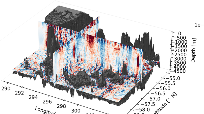
The Indian Ocean plays a crucial role in the abyssal overturning circulation, transforming Antarctic Bottom Water (AABW) into lighter water. In the western Indian Ocean, the only path for AABW to reach the subtropics as part of the global overturning is through the fracture zones of the Southwest Indian Ridge. This mid-ocean ridge has seven known fracture zones in this area, but until recently, only Atlantis II has been investigated, given the historical shortage of in situ observations in the region. To address this gap, we collected as part of the Deep Madagascar Basin (DMB) Experiment (DMB) the first comprehensive surface-to-bottom measurements of velocities, water properties, and tracers at four fracture zones deemed to transport AABW northward - Gallieni, Atlantis II, Novara, and Melville. Based on these new observations, we estimate the relative contributions of each fracture zone to the overall northward transport in the abyss and assess the strength of diapycnal turbulent mixing. Our observations reveal two strong northward deep jets transporting AABW, one at the Novara (46.0 cm/s at 4,370 dbar) and another at the Melville (23.8 cm/s at 4,360 dbar) fracture zones, and provide evidence of the persistence of the previously observed Atlantis II jet. Contrary to earlier assumptions, we find that the Melville fracture zone, rather than the Atlantis II, is the primary contributor to the northward transport of deep and bottom water, at least during the DMB period.

Editor's Highlight: Overturning Ocean Water by Turbulence

Our recent paper in AGU Advances (see below!) was chosen as an Editor’s Highlight - as explained by Nicolas Gruber in Eos.

Boundary Upwelling of Antarctic Bottom Water by Topographic Turbulence (AGU Advances, 2023)

The lower cell of the meridional overturning circulation (MOC) is sourced by dense Antarctic Bottom Waters (AABWs), which form and sink around Antarctica and subsequently fill the abyssal ocean. For the MOC to “overturn,” these dense waters must upwell via mixing with lighter waters above. Here, we investigate the processes underpinning such mixing, and the resulting water mass transformation, using an observationally forced, high-resolution numerical model of the Drake Passage in the Southern Ocean. In the Drake Passage, the mixing of dense AABW formed in the Weddell Sea with lighter deep waters transported from the Pacific Ocean by the Antarctic Circumpolar Current is catalyzed by energetic flows impinging on rough topography. We find that multiple topographic interaction processes facilitate the mixing of the two water masses, ultimately resulting in the upwelling of waters with neutral density greater than 28.19 kg m$^{-3}$, and the downwelling of the lighter waters above. In particular, we identify the role of sharp density interfaces between AABW and overlying waters and find that the dynamics of the interfaces’ interaction with topography can modify many of the processes that generate mixing. Such sharp interfaces between water masses have been observed in several parts of the global ocean, but are unresolved and unrepresented in climate-scale ocean models. We suggest that they are likely to play an important role in abyssal dynamics and mixing, and therefore require further exploration.

The Impact of Representations of Realistic Topography on Parameterized Oceanic Lee Wave Energy Flux (Journal of Geophysical Research - Oceans, 2022)

Oceanic lee waves are generated when quasi-steady flows interact with rough topography at the bottom of the ocean, providing an important sink of energy and momentum from the mean flow and a source of turbulent kinetic energy. Linear theory with a spectral representation of topography is typically used to inform parameterisations of lee wave generation. Here, we use a realistic wave resolving simulation of the Drake Passage, a hot-spot of lee wave generation, to investigate the utility of such parameterisations for areas of complex large scale topography. The flow is often blocked and split by large amplitude topographic features, creating an ’effective topography’, and calling into question the spectral representation of small scale topography for lee wave generation. By comparing the resolved modelled wave field to parameterisations employing various representations of topography, we show that spectral methods may not be appropriate in areas of rough topography. We develop a simple topographic representation consisting of an ensemble of topographic peaks, which allows physical treatment of flow blocking at finite amplitude topography. This method allows better prediction of bottom vertical velocities and lee wave energy flux than spectral methods, and implies that the nature of lee waves in such regions can be misrepresented by a spectral approach to topographic representation. This leads to both an overestimate of wave energy flux and an underestimate of wave nonlinearity, with implications for the mechanisms by which lee waves break and mix in the abyssal ocean.